


Here’s a place. Squeezed in between the United States and Greenland. Canada.
Best to stand right-way up.
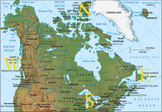
Lately, I’ve heard the strangest thing. I’ve heard that my part of the country…
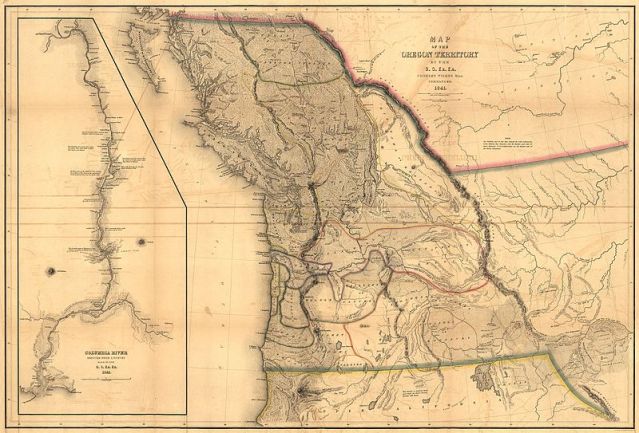
… is called the Southwest. The Canadian Southwest. This was in reference to the name the region often goes by: the Pacific Northwest. Here it is in 1844, just before the 49th Parallel Canadian border (pink and grey on the right) was drawn across it, cutting it in two.
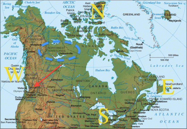
That’s an American view, on an American military map. You can see the remnants of the Canadian Northwest in the following image (note the blue oval). As you can see, it goes right up into the Arctic. In fact, a quarter century ago, it was all of the Canadian Arctic, right up to Greenland.
If you didn’t know the place, you might think this Southwest Canada stuff made sense. Ah, that’s where politics come in. For Instance, in 1752, the best map looked like this:
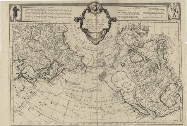
Note the big sea where there is no sea.

Basically, this part of North America (under that sea that is not a sea but possibly a memory of glacial melt events 12,000 years ago) is un-mapped. Here it is (below) in 1756. As you can see, no map of the region at all, really.

And 1795. By this time the coast is mapped…but nothing else. As I mentioned above, there is a name for this “empty space.” It is the Pacific Northwest.
It comes by this name along two routes. First, as the map below shows well, it is Northwest of what was then the centre of European civilization in North America, the Caribbean, which was colonized by the Spanish in 1492.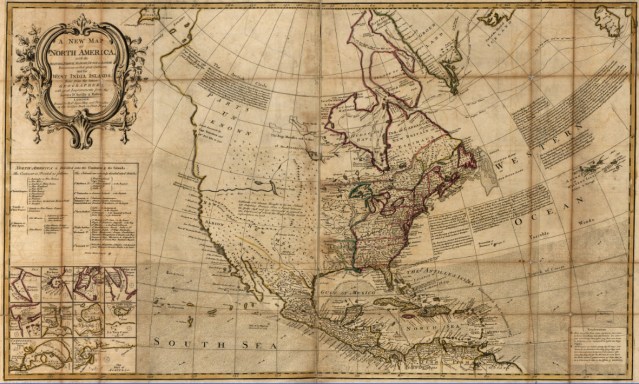
Yup, that’s where I live: in Parts Unknown. Note the totally inaccurate Columbia River at the bottom, but, hey, at least it’s there.

This was a continent controlled by Spain (Southwest) and France (Northeast, and the centre of the continent, right down to the Gulf of Mexico), with tiny English colonies on the East Coast (later the United States) and an English trading area in the Far North. Much of Southern New France eventually went to Spain, and from there to the United States, in the Louisiana Purchase. Much of New Spain went to the United States in the American-Mexican War. But that great empty area, the goal of exploration, remained the Northwest.
So, that’s the first Northwest. The second has to do with the English and French colonies on the east coast. Here’s a later map (below) of New France. In my part of the country, this is called the East, although there it is called the Centre. The English colonies are on the far right. Everything else is French.

In other words, everything is the West, except for a narrow strip along the Atlantic. That’s the English view. The French view was that everything was the West that was West of Montreal. Here’s Montreal (below), the trading city of New France. The wealth of a continent, north, west and south, flowed through here:

No surprise that the trading company out of Montreal was called the Northwest Company, since it traded in those regions of New France that were north of old French territory on the Gulf of Mexico. Here’s a Northwest map.
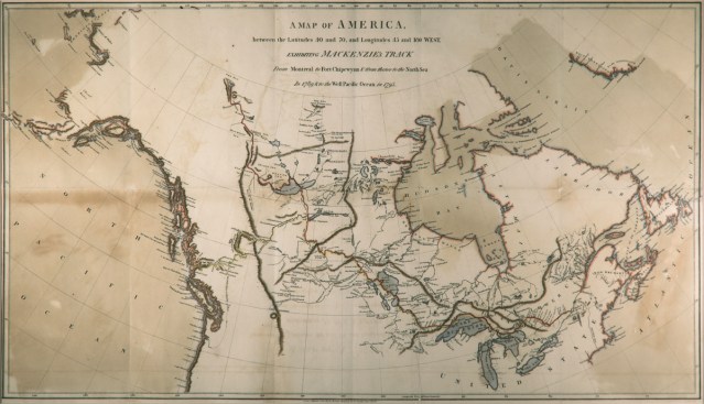
There are many others. Here’s one from 1810 that shows the Northwest interests in today’s United States. Note that Oregon Territory (today’s Pacific Northwest) is the territory of Great Britain, the United States and Spain. Below it is Mexico. In the centre of the continent is Lousiana (now Spanish). To the right is the expanded United States, with British Territory to the North. France is out of the picture. The red arrow is St. Louis.

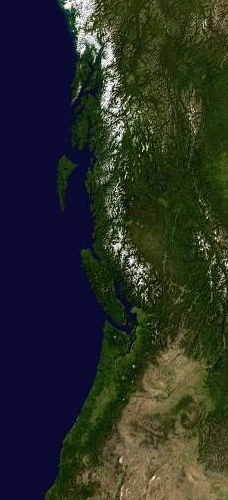
St. Louis was the American fur trade headquarters, for all fur trading into Louisiana and Mexico. Canadian trade was still coming West from Montreal, in what is now known as Lower Canada (in the upper right.) By this time, the eastern part of the Northwest is now called the West (today’s Mid-West) and Louisiana is still largely French-speaking. Please note that those families did not go anywhere. They are still there, but had a new culture, and a new language, given to them by colonization from the United States. The only area unexplored at this point was that area claimed by three countries in the upper left. It was politically dangerous to explore it. It was only when Spain was knocked out of contention, and it was just a disputed region between Britain and the USA, that it was given a Name: Oregon. Or the Pacific Northwest, to distinguish it from the other Northwest, which was now in the middle of the continent. Here is my Northwest, in a satellite view. Isn’t she beautiful? We call her Cascadia now.
She has an old history, rooted in the French people who moved across the continent and intermarried with indigenous families, and took on their cultures. The arrow shows where I am living as I talk to you about this.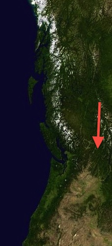
To call this the Southwest of Canada is a complete erasure of a long French history, over three centuries older than the nation state of Canada and of the history of this place. The people of this history are Canadians, with more right to the term than most citizens of the nation state. Our heritage here is primarily with people in Quebec (Lower Canada), Washington, Oregon, Idaho, Montana, Northern California and Wyoming, and secondarily with the North and with the French culture on the Prairies. Canada, the 1867 British nation state, comes a long, long, long way down the list. It’s not that we’re not proud to belong to Canada here, but our history does not live within these borders:
We’re proud of that, too, because it is that old history that makes us who we are, not the new history of a country still trying to reshape it. So, the Pacific Northwest, or Cascadia, please. We are citizens of the continent out this way.


Love the history and the old maps. I used to work as a cartographer and love maps and geography. Thanks for putting this together.
LikeLike
You’re welcome. It would have taken a dozen hours to do it right, but it’s all I could manage at the moment. It’s hard to find some maps that I have seen before.
LikeLiked by 1 person
What a great post! I’m a Seattle native who took a NW history class at the University of Washington as part of my undergrad and your descriptions are in line with what I learned–except, your maps are better 🙂 I especially like the one that labels “Parts Un-Known.” Thanks for the great work!
LikeLike
Thanks, Jennifer! You inspire me to go hunting for the maps I couldn’t find. I should tag these things better! Best, Harold
LikeLike
🙂 You’re very thorough. Well done!
LikeLike