


I spent the early winter reading a beautiful and, unfortunately, incomplete book: Crossing Home Ground, by David Pitt-Brooke. It records an epic walk through the grasslands of Southern British Columbia: my own home ground. My detailed review was just published today in The Ormsby Review. You can read my review here (with beautiful photos by Pitt-Brooke): http://bcbooklook.com/2017/01/26/in-praise-of-grass/#more-30105. I’m thrilled that it is out. My goal in writing the review was to honour the book and the conversation of which it is a part. I’d like to show you a few images from that context. They are beyond the scope of the book, but help to anchor its discussions, I think. Here’s the mouth of the Okanagan River, as it enters the inundated Columbia. It is here that the private armies that invaded the Okanagan in 1858 crossed the big river on their way north, and it is here that scouts tagged invaders for later skirmishes in the Okanagan and Similkameen.

This is The Forks, a major stopping point on the ancient trail to the deep north and the Hudson’s Bay company brigade trail that followed it. It is here that the route forked, to the Similkameen Valley to the distant left (the trail is a county road now, as you can perhaps make out), and to the Okanagan to the right. The image shows the Similkameen River joining the Okanogan.T
This is some of the Similkameen Grassland, above the Similkameen Gorge and looking towards Hurley Peak in the Pasayten Wilderness. Pitt-Brooke camped high above this country, just over the Canadian Border behind you as you view this grassland, and looked down on it at dusk.
High up on Kruger Mountain to the left in the image below. This is Richter Pass. That green hayfield in the bottom is lost Richter Lake, drained to grow sileage corn. This is British Columbia. The Washington side (above) is in better shape.

He saw farms down there in Washington. Well, mines. The grass in this country, as Pitt-Brooke accurately points out, is damaged, but not irretrievably. Here is some grass and sagebrush above Nighthawk, Washington.
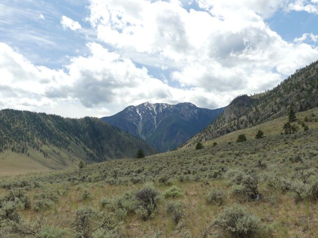
Areas directly on the Hudson’s Bay Company Trail, such as Garnet Valley below, have suffered the worst — grassland ruins that have not created a lot of prosperity, either.
Here’s one of the culprits at work in Priest Valley, above my house in the North Okanagan. She is being grazed on a landscape of invasive weeds. That’s dalmation toadflax around her. You can see she doesn’t like it. Rush skeleton weed, though, well, she likes that. Almost all the bunchgrass is gone. That looks like a stalk of needle-and-thread grass in her mouth.

That missing grass is the original human habitat, and almost none is left on earth. Our bodies were made for this landscape. This is who we are. Luckily, there is some left. Here’s some bunchgrass that is grazed responsibly in Farwell Canyon, in the Chilcotin.

This is the grass that Pitt-Brooke loves. So do I. Please read David’s book, and then go out yourself to see what you can see. You might see wonders, like the virtually pristine grassland in the bed of Dry Falls, a waterfall that was once 30 miles long, falling 300 feet over these basalt flood lavas, from a river 300 feet above them. The only weed here is one stalk of toadflax in the foreground.

Before this became a Washington State Park, it was a ranch. The grass came back. We can do this.
Categories: Erosion, Ethics, First Peoples, Grasslands, History, invasive species, Land, Land Development, Spirit, Urban Okanagan


