


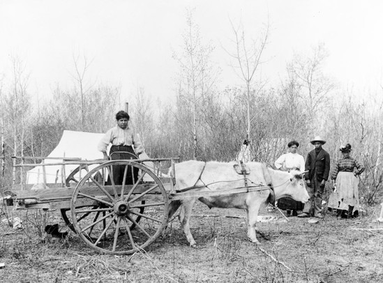
OK, a little secret. Cascadia, the Pacific Northwest of North America, evolved in Rupert’s Land, far to the Northeast, and in a colony called Assiniboia, centred on the Red River on the Great Plains. What’s more, my family history is in there, and the present state of affairs. I’ve lived 65 of British Columbia’s 165 years now, with a family memory that covers 94 of those. That’s 57%. Here are my grandparents building their first house in 1930, in their stump farm at Stave Falls, what we would today call a clearcut. Materials are largely wood split or milled from logs left lying on their land, some sawmill rejects, and some free-for-the-taking shipping pallets. Doors, windows, stairs and any interior trim were shipping palettes.

Yes, This is the Whole House
Note that the ladder is also home made and that the foundation is more wood. Judging by the twist in it, it’s likely a reject from a local mill. Martha was the secretary of a theatre troupe back in Germany, and Bruno was known to strum a guitar on stage for her. You can see them here putting their theatrical training to good use. Look at Martha holding that hammer just so. Good girl.
It is important to hold on to the simple truth that Cascadia (and the house above) was not in Rupert’s Land for 150 years. Even after it did, in 1821, it was not a country but a private trading district. Assiniboia was never a country, either, although it should have been. Let’s call them cultural spaces instead. Meeting grounds.
The Métis People, Children of the Fur Trade, Populated Assiniboia
They saw themselves as British. The British didn’t.
Far to the west, British Columbia, which was an independent colony from 1858 to 1871, came close to being a country, too. So did the colony of Vancouver Island (1849-1866) before it. They were the only parts of European-dominated Cascadia with the distinction of independence. Oregon turned from it by 1859, although it was in the cards. There were many countries here before these colonies, of course, but they don’t show up on the map below.

Rupert’s Land: the Drainage of Hudson’s Bay
The region was gifted as a trade monopoly to the Hudson’s Bay Company (sight unseen) by King Charles I in 1670, under the governorship of his cousin, Prince Rupert of the Rhine, Duke of Cumberland.
Rupert himself was a naval commander during the English Civil War, was exiled during the English Revolution, and returned to leadership after the Restoration. Here he is as he would like to be remembered.

The painting was made by the Dutch refugee Peter Lely. Interestingly enough, Rupert, a Scots-Czech, spent much of his professional life fighting the Dutch. Rupert was also one of the founders of the Hudson’s Bay Company. Other founders included Sir George Cateret, who had become a multi-millionaire as a pirate preying on Cromwell’s forces during the English Civil War and Lord Ashley, Chancellor of the Exchequer, the man responsible for British public finances. And, obviously, for his own.
The charter of the company was direct:
The sole Trade and Commerce of all those Seas, Streights, Bays, Rivers, Lakes, Creeks, and Sounds, in whatsoever Latitude they shall be, that lie within the entrance of the Streights commonly called Hudson’s Streights, together with all the Lands, Countries and Territories, upon the Coasts and Confines of the Seas, Streights, Bays, Lakes, Rivers, Creeks and Sounds, aforesaid, which are not now actually possessed by any of our Subjects, or by the Subjects of any other Christian Prince or State […] and that the said Land be from henceforth reckoned and reputed as one of our Plantations or Colonies in America, called Rupert’s Land.
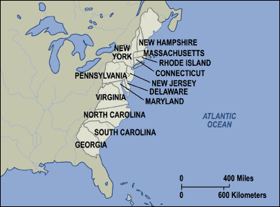
Rupert’s land, in other words, was something like the English colonies in the Carolinas. In fact, the treasurer of the colonies in the Bahamas and the Carolinas, John Portman, poured funds into the enterprise. A good way to think of it all is to set aside the map of the 13 English colonies in North America that lead to the United States …
… for the more complete one, that looks like this:

The pink bits above are claimed by the English. Note that Nova Scotia and Newfoundland never joined the revolution. Note as well the map below, which shows how French and English claims overlapped.
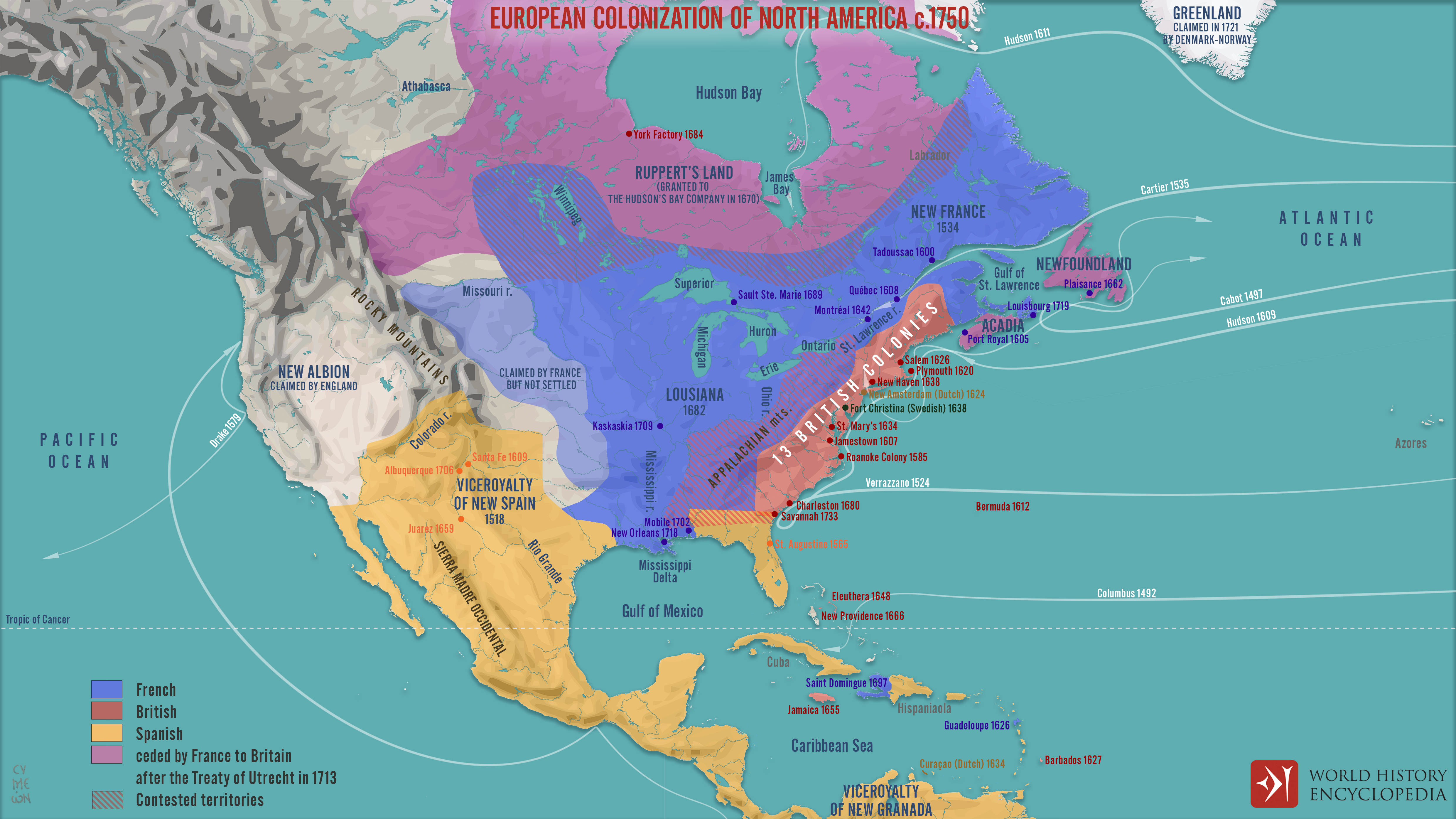
That is, before the English gained New France nine years later and everything North of the 13 colonies became English. Note as well New Albion in the West. The English claim to California is a bold move, given that the land was occupied and administered from Spain! Very sneaky stuff. Kind of like the Hudson Bay Company’s claim to be English!

1682-1707
Avprivate version of the English flag, St. George’s Cross, spreading across the world but returning to the HBC, not to England. Expertly done.
All-in-all, the Company was a great work-around to parliament: a way to create an empire without the need of either a navy or government oversight, and without the need to channel its profits into the public treasury. Rather than there being 13 English colonies in North America, there were 16, covering half of the continent. Only 13, a small geographical area, rebelled. Expecting Rupert’s land to rebel, of course, would have been foolish. It was founded by anti-revolutionary royalists in the first place. What’s more, their mandate prevented them from settling (which would have created a need for all the expenses of a state presence, and they weren’t interested in paying for the state, not when parliament controlled it and not them.) Remember that all this took place after the English Civil War.
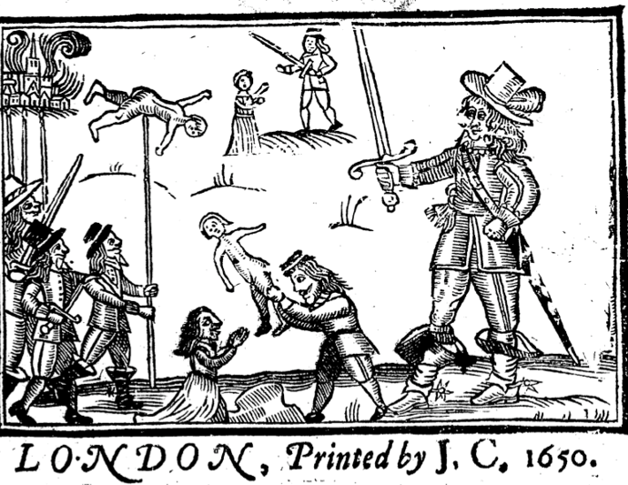
A Bit of Revolutionary Propaganda
The illustration purports to show royalist troops (such as Prince Rupert) murdering babies for sport. Sadly, the same horrible lies were told about the German advance through Belgium during the Great War of 1914, to encourage the British people to turn against their natural ally, Germany, and join their traditional enemy, France. Fake News is not new.
In the end, the English Civil War saw the expulsion of royalty from England and the declaration of an English, Welsh, Irish and Scottish commonwealth under the de facto dictator Oliver Cromwell. During that struggle, parliament gained power. When royalty returned nine years later, in 1660, it was with the indulgence of parliament and subservient to it. It was only ten years later that the anti-revolutionaries in the British administrative and aristocratic class (largely royalist counter-revolutionaries) cooked up the plan for Rupert’s Land. For a contemporary equivalent of such goings-on, we need only look to the incredible profits made by the American firm Halliburton, with its presidential ties, in Iraq…
Houston-based energy-focused engineering and construction firm KBR, Inc. (NYSE:KBR), which was spun off from its parent, oilfield services provider Halliburton Co. (NYSE:HAL), in 2007. The company was given $39.5 billion in Iraq-related contracts over the past decade, with many of the deals given without any bidding from competing firms, such as a $568-million contract renewal in 2010 to provide housing, meals, water and bathroom services to soldiers, a deal that led to a Justice Department lawsuit over alleged kickbacks, as reported by Bloomberg.
Source: https://www.businessinsider.com/halliburton-company-got-395billion-iraq-2013-3
…or the ongoing profiteering of American and European oil companies in Azerbaijan, closely aligned to American projections of military might, largely built at public expense to defend them. Sudan is an even better example. The oil industry was created by the American company Chevron in 1974, before it pulled out in 1996, ostensibly due to political fallout from the First Gulf War, leaving the field open to China and India. Only 10 years later, the oil fields were depleted. Coincidence? Today, Sudan produces 140,000 barrels of oil a day. Canada, on the other hand (well, Rupert’s Land) produces 2,840,000. t all rather looks like a good economic reason to pull out, similar to the reasons that caused Napoleon to sell Louisiana to the USA in 1803. Imagine the luxury of an empire, pulling the wealth out of a continent without the cost of defending it militarily like this!

US Marine Corps M1 Abrams tanks patrol a Baghdad street after its fall in 2003. Each tank costs approximately $9,000,000, adjusted for inflation. 10,400 were built, or about $93,600,000,000. To compare, that’s 10% of the annual Canadian economy and 50% of the current economy of Iraq.
According to a Congressional Budget Office (CBO) report published in October 2007, the US wars in Iraq and Afghanistan could cost taxpayers a total of $2.4 trillion by 2017 including interest. The CBO estimated that of the $2.4 trillion long-term price tag for the war, about $1.9 trillion of that would be spent on Iraq, or $6,300 per US citizen.[7][8] A CRS report (conducted after the 2010 end of combat operations and 2011 withdrawal) was released in December 2014. It placed the cost of the war operations in Iraq as of January 1, 2014, at $815 billion out of the total $1.6 trillion approved by Congress since September 2001.[9]
Source: https://en.wikipedia.org/wiki/Financial_cost_of_the_Iraq_War
Compared to all that, aristrocacy (and its Rupert’s Land project) is a bargain. This was land set aside for trade by a consortium of British aristocrats. In 1811, it granted land to Lord Selkirk. This land was not a trading post.. This was Assiniboia. It was to settle landless Scottish peasants (dispossessed of their aboriginal lands by the creation of large aristocratic estates able to build concentrated industrial capital out of large-scale sheep-grazing) on Northwest Company lands settled by Métis people, who, being of the land, didn’t exactly adhere to the English law that said they couldn’t settle there.
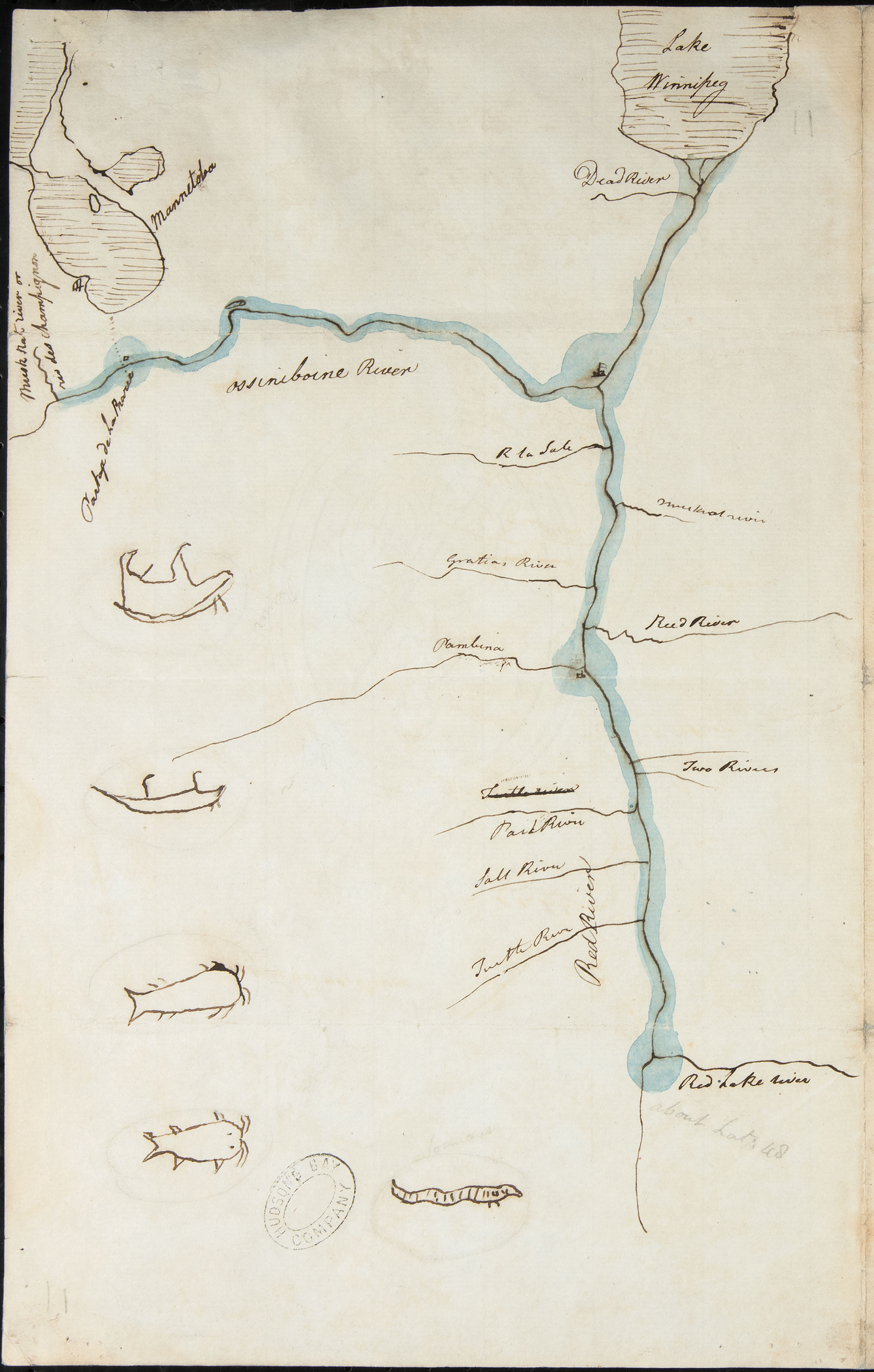
Assiniboia
It started off a little sketchy in 1811.
By 1817, it had a right proper map.
.

Note that Half of it is South of the Current US-Canadian Treaty Line (The 49th Parallel)
Now, just one other thing. The Hudson Bay Company was built on the labour of men from the islands in the north of Scotland, and by the French. Here’s a map that might put that into perspective:
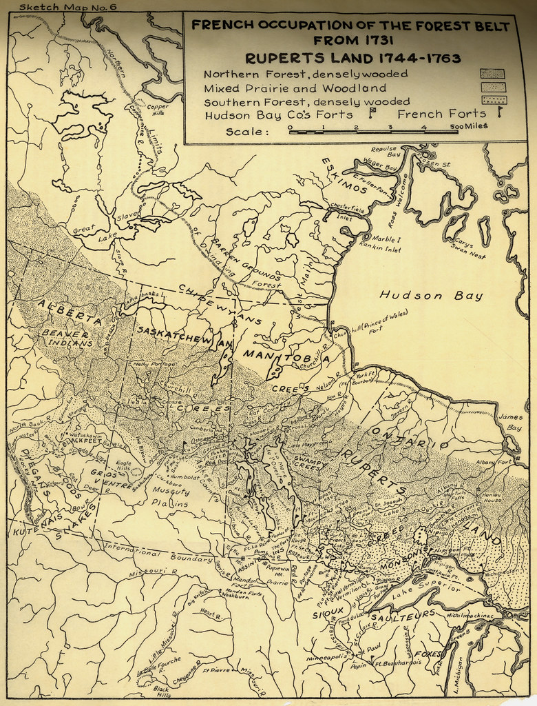
The French (from Montreal to the east and Louisiana, the southern part of this map) claimed the forest as their trading area, and they were present throughout it, even long after the fall of New France. Here they were free of colonial politics, unemployment, and job replacement by British immigrants, as was the case in Quebec. In a way, out here in the West, New France continued, long past the fall of Quebec and even the sale of Louisiana to the USA in 1803. And into the middle of this freedom, with centuries of history behind it, in land that the Northwest Company brazenly tramped through, falls Assiniboia?

That’s a lot of competing claims!
And there are more claims than just that:

Anishininiimowín, Anishinabewaki, Sisseton, Bdewakantuwan, Yanktonai, Assiniboine, Michíf, Scots, English and French, as well as the Shetland and Orkney men and some Black people, too. Not to mention the Indigenous boatmen from Kahnawake.
The trick was going to be in building alliances. I am showing you this series of maps, so we can see together how the fate of the Columbia District was decided and what kind of forces were at play. It was, at heart, an extension of an English landed estate. Kind of like this:
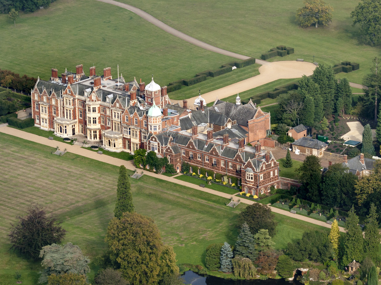
Note the little Shepherd’s Hut near the grotto in the bottom right-hand corner. De rigour. Here it is in its 20th century version, a year after construction:

The bothersome logs are gone, but look at the potatoes and the baby, too. That’ll be my Uncle Frank, now passed, sadly.
There’s a lot more to Assiniboia than meets the eye.
~
Next: Assiniboia as a Reservation.
Categories: History, Nature Photography


3 replies »